|
|
Post by apairon on Jun 28, 2005 22:21:16 GMT
www.moebius.mynetcologne.de/map/map_woking_small.jpgThis map might help first readers. It is of course a modern aerial and you have to imagine the towns to be way smaller. Also the strong grey streaks weren´t around in 1901 - highways. The large more horizonal streak tho is the railway and i assume it to have changed little. I´d like to see waterways on it but am not able to find any.
|
|
|
|
Post by Gnorn on Jun 28, 2005 22:55:25 GMT
|
|
|
|
Post by lanceradvanced on Jun 29, 2005 3:26:24 GMT
|
|
|
|
Post by Poyks on Jun 29, 2005 3:42:57 GMT
Sorry, couldn't resist!! ;D 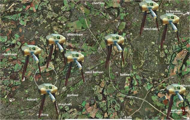 Seriously though, it is good to be able to put the story into some kind of perspective and (literally) scale. |
|
|
|
Post by mctoddridesagain on Jun 29, 2005 9:30:35 GMT
Soopoib!
;D
|
|
|
|
Post by apairon on Jun 29, 2005 9:56:20 GMT
 worst FM ever. |
|
|
|
Post by mctoddridesagain on Jun 29, 2005 10:14:42 GMT
You've not seen Pendragon's fillum, then?
|
|
|
|
Post by apairon on Jun 29, 2005 11:21:09 GMT
I added shepperton and send.
ask me about a version with twice the resolution via email. (2,6 mb)
|
|
|
|
Post by Poyks on Jun 29, 2005 13:44:31 GMT
worst FM ever. You better believe it! ;D ;D |
|
|
|
Post by Victorian Squid on Jun 29, 2005 16:05:17 GMT
Brilliant stuff! Has anyone got any maps of Surrey from the time the novel was written? I seem to remember sombody posting a Victorian map of Woking village and Horsell a while ago, but how about further towards London?
I was a bit disappointed with the map in the Penguin special edition as it's a little vague. It would be interesting to really try and pin down what would have more or less been the extact route of the narrator, although I realise that the detail isn't always there.
Anyone already done this or thought about it?
VSx
|
|
|
|
Post by Gnorn on Jun 30, 2005 19:50:04 GMT
I used to have copies I had made at a library or archives (not sure which anymore) in London, but can't find them anymore, I fear I threw them away. But that would be your best shot, to go to the archives in London or Woking.
-Gnorn
|
|
|
|
Post by Victorian Squid on Jul 1, 2005 1:24:50 GMT
Yep, local archives are a good bet - I think the old map was linked to the Woking Civic Society website or something. I've kept my eye open for old maps on eBay, but the best place for those are local bookshops and chariddy shops - must make a trip down there later in the summer.
Have any other WOTW route maps other than the recent Penguin one ever been published, in HG Wells Society journals or the like?
|
|
|
|
Post by Lensman on Jul 1, 2005 5:27:57 GMT
|
|
|
|
Post by Max on Jul 17, 2005 6:29:45 GMT
Taking a holiday and travel from Woking to Primrose Hill is something i've wanted to do for about 20 years now.
But i figured (A) it must take a heck of a while and (B) things like the M25 could really bugger things up.
A much more sensible idea, and one i plan on doing this summer, is to follow the narrator at the end of the book as he travels back through London.
I'm either going to start just south of the river or from the Natural History Museum and then up to Primrose Hill.
Either way, a day should cover it and there's the bonus of Wells being very precise on the route he took and London in those areas still have the Victorian road layouts.
|
|


 worst FM ever.